
In the Coquimbo Region advances in the way that rock glacier inventories are made is important, due to the desertification, the decrease of precipitation and the presence of 656 of this type of landforms.
Everyday you probably upload pictures to your Facebook account, and the same system suggests that you tag your friends on the image, automatically. Maybe this morning you logged in to your phone or computer using facial recognition as a password; or perhaps you have watched a video on YouTube automatically subtitled in your native language. All those features are part of so-called “deep learning” technology, an algorithm or orderly operations, which are executed by a computer in order to collect information, process it human-brain-like, and give it back as part of a response, in different contexts.
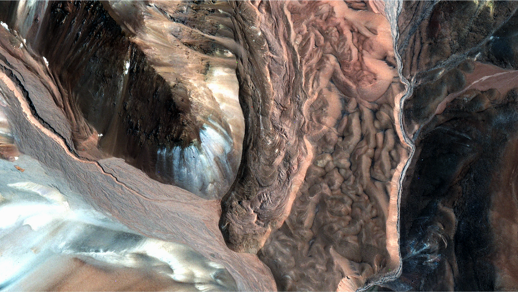
Deep learning was developed by big digital companies, such as Google, and recently a group of researchers adapted this approach for the recognition of rock glaciers in La Laguna catchment, Cordillera de Los Andes, at the Elqui Valley, Coquimbo Region, and also in the Poiqu catchment, in central Himalaya.
The study showed promising results. Utilising freely available satellite imagery and 120 selected rock glaciers for analysis, deep learning identified 108 rock glaciers in total. Within the testing of the algorithm the scientists realised that expensive high resolution satellite imagery doesn’t necessarily equal better glacier rock detection rates, even though deep learning showed more accuracy identifying those geoforms with this last type of imagery.
Dr. Benjamin Robson from the University of Bergen, Norway, lead author of the paper, said in order to refine the search for rock glaciers within the study they combined the use of deep learning with Object Based Image Analysis (OBIA) techniques. This method combines similar pixels next to each other into an object. For example, one object could be a lake, another could be a landslide, and a third one could be the lobe of a rock glacier. So, OBIA could allocate a given classification to a complete object, rather than to individual pixels, to improve the final result.
“We wanted to combine freely available satellite imagery along with deep learning to recognise rock glaciers by their surface morphology … we hoped that the landforms we could detect would be the largest with the most prominent morphologies and therefore potentially have the highest ice contents. We found however that there were other landforms that had similar spectral patterns as rock glaciers, for example avalanche deposits, or in some cases fluvial or glacial deposits. Therefore we decided a novel aspect of the method would be integrating deep learning with object based image analysis (OBIA). OBIA allows us to refine the classification by shape, size, and contextuality, meaning we could try our best to exclude landforms that were not rock glaciers”. Dr. Robson explained.
Robson clarified that a manual method will generally be more accurate than automated ones, especially when it needed to recognise complex forms as the rock glaciers ones. According to the researcher there will always be cases where the machine won’t be able to identify certains features.
“Our aim was not to match the accuracy of manual mapping, but to develop a method that can create a “baseline” product which identifies the largest landforms in a catchment. In order to create an inventory you would still need to edit the results to account for errors, but hopefully the amount of time editing will be significantly less than the time needed to create an inventory from scratch”, he added.
Dr. Robson pointed out that other studies had used texture images to recognise rock glaciers, but none of them had integrated deep learning with OBIA . He expects that the method he developed may be more transferable to different regions, since its effectiveness has been tested in two different parts of the planet already.
“At least compared to the few studies out there that have mapped rock glaciers automatically, I think our method worked over a larger area and was more transferable (since we applied it in two areas). I think the next step would be to try it out on a larger region, and eventually try to train the model to separate between active and inactive rock glaciers. I am not sure if this is possible, but it would be very interesting”, said.
Outcomes applied to the Coquimbo Region
In the Coquimbo Region advances in the way that rock glacier inventories are made is important, due to the desertification, the decrease of precipitation and the presence of 656 of this type of landforms in that part of the country, approximately, according to information from the Chilean government (Dirección General de Aguas). In this framework, Dr. Shelley MacDonell, head of the glaciology laboratory at CEAZA research center and one of the authors of the paper, said the technique will increase the ability to mapping large areas relatively quickly. She thinks potentially the technology might be possible to use it in future to automatically study rock glacier changes.
“Probably we will no longer need a dedicated person in the laboratory to spend all their time laboriously mapping rock glaciers. From the output of this method, we only need somebody to check the final product, which means we free up people to work on other problems, such as analysing why rock glaciers may be changing, and how this will impact water resources” Dr. MacDonell explained.
MacDonell also said the potential use of this technology to recognise active and inactive rock glaciers could help to estimate the amount of ice reserves in them.
“Used in the right way, these technological advances will greatly improve our ability to understand our hydrological system, and provide better baseline information for decision makers”, the scientist posed.
Also worked as a co-authors of the study Dr. Tobias Bolch (University of St. Andrews, United Kingdom), Dr. Daniel Hölbling (University of Salzburg, Austria), Dr. Philipp Rastner (University of Zurich, Switzerland), Dr. Nicole Schaffer (CEAZA).
You can see further details of the study in the following presentation of Dr. Robson:
Patricio Jofré